Black Magic, Stream Orchids, and a Wet Monkey in a Tub

Mimulus cardinalis
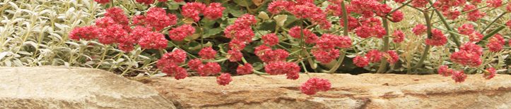
Our wet monkey, Mimulus cardinalis, has started blooming. There are two kinds of monkey flowers, ones that like wet soil and ones that like dry soil. The dry monkeys (also sometimes called sticky monkeys, preferably with a faux-British accent) are starting to get listed as Diplacus, instead of Mimulus, which makes some sense to me, even though the switch also causes some confusion. There’s not really anything similar about the wet and dry types — not the foliage, the form, the habitat, the cultural needs, and not the flowers — so I’m not sure how they got grouped together in the first place. Las Pilitas has a page devoted to the various monkey flowers that talks about the differences. I’ve grown a few different types of wet monkey flowers, but the only one in our garden now is the scarlet monkey flower in our bog planting.

Colocasia Black Magic and Mimulus cardinalis
Our bog planting is set inside an old cast-iron bathtub dug into the ground and covered over with mulch. The idea is that the water drains more slowly than it would in open ground, so we don’t have to irrigate these water-loving plants as often as we would otherwise, a way to keep our garden low-water without excluding all the plants we’re interested in growing. We filled it with 2/3 soil and 1/3 compost, which is a ton of amendment by our standards. The only outlet from the tub is the open drain at the bottom and we water it the same amount and on the same irrigation zone as the moderate-water section of the yard where we have the blueberries, the mock orange, the heucheras, the astilbes, and our young citrus tree, plants that you wouldn’t normally expect to share an irrigation zone with a colocasia, which is often grown directly in ponds and fountains.

Black Magic stems
Colocasia “Black Magic,” aka Elephant Ears for its big leaves, is a very cool plant. It’s in the low part of our yard, so we don’t have a good view of the black stems, though the stems are my favorite feature of the plant, even more so than the leaves. We also have Yerba Buena (Satureja douglasii) and Yellow-Eyed Grass (Sisyrinchium californicum) hanging out under the colocasia, and a canna growing behind it. This is the third summer for the planting, and the colocasia has steadily increased, while the canna seems to be fading.

Stream Orchid, Epipactis gigantea
Last month the Stream Orchid, (Epipactis gigantea) was the main bloomer in the tub. It still has a few blooms, but it’s mostly finished now. Not a showy flower, but interesting up close.

Stream Orchid, Epipactis gigantea

Epipactis gigntea and Mimulus cardinalis
I feel like the scarlet monkey flower doesn’t even have the same color tone as most California natives. It’s more like the nasturtiums which come up as volunteers in our yard. A yellow one recently came up in the bamboo behind the bathtub, so we’re hoping it will ramble out into the monkey flower patch before the monkeys stop blooming. It’s a little surprising to me that a California native would combine so well with colocasias and nasturtiums, but I guess I should know better by now. Photos of wet and dry monkey flower buds (the one similarity I find between the two kinds), the yellow nasturtium, and a raunchy close up of the stream orchid are below. Read the rest of this entry »
Trudy the Corpse Flower

Trudy the Corpse Flower
You can catch flies with honey, but you can catch even more with the stench of carrion. I went to see Trudy the corpse flower blooming at the UC Botanical Garden in Berkeley. Corpse flowers (Amorphophallus titanum) earn that lovely goth name by exuding the stench of rotting meat to attract flies to act as pollinators, and they’re not shy about it. The smell is potent, Trudy filed the UC glass house with the smell of roadkill goat, and it’s effective, too; there were ten or twenty flies buzzing around it while I was there, and apparently there’s a bigger swarm in the morning when the smell is strongest. And it’s all a con job on the flies; they lay their eggs thinking there will be food for their offspring, but the children hatch and starve without a genuine carcass to feed on.
The flower is six feet tall and impressive even without the stench. Corpse flowers are from Malaysia and they take seven or more years to bloom, waiting until the plant’s corm weighs thirty pounds or more. The bloom, which is actually a collection of little flowers, has a claim as the biggest inflorescence in the world, and the spadix (the big spike sticking up in the middle) generates heat, up to twenty degrees warmer than the ambient temperature. Someone at the garden has a sensor set up to test if the plant gives off a biomagnetic field the way humans and animals do.
This particular corpse flower, Trudy, first bloomed in 2005 at age twelve, and then waited four years to bloom again, making this her second time blooming, though the garden has others which bloomed while Trudy was resting. The bloom will only last a couple of days before it gets pollinated and collapses. The garden’s website has tons of photos and regular updates. For years, we’ve been getting emails every time one of them blooms, but this was the first time I went by to check it out, and, I gotta say, it was pretty cool. There are seedlings for sale if you want to pay thirty dollars for an indoor plant that requires constant watering and feeding and smells like carrion when it blooms. Photos of nice-smelling flowers are below. Read the rest of this entry »
Brodiaea Agapanthaflora?

Brodiaea
I’m a pretty loyal California native planter, but I had my confidence in one of the native bulbs, Brodiaea, shaken recently. We’ve been planting “Corrina” and “Queen Fabiola” for a couple of years, and they’re good small bulbs for our area — they have lovely blue flowers, they don’t take much space, and they don’t require any irrigation, you just fall-plant and walk away. But then a friend of mine said they looked like Agapanthus. Ouch.

agapanthus
That might not sound like a big deal to non-Californians, but around here agapanthus is the omnipresent strip-mall/sub-division/highway-median plant. Plenty of gardeners from other areas seem to like it — for instance, Garden Design magazine recently featured a French garden named Le Jardin Agapanthique, which to me is like naming it the Privet Garden — but it gets no love here. The flower is okay, I guess, but the foliage is too glossy for our landscape; it looks plastic and fake next to the more silver and gray foliage of other low water plants. I sort of respect the plant’s bomb-proof toughness — I once dug a bunch out of the ground and dumped it all in a pile in the sun in the middle of summer and three weeks later it was still blooming — but I’ve demoed a lot of it, and I find that it’s always heavy, it’s always full of snails, and it always leaves behind nasty wormlike white roots. My apologies to any agapanthus gardeners out there, but I don’t like it.
So it’s kind of disturbing to think that Brodiaea resembles agapanthus. Do other people see the similarity? There’s a photo of the Brodiaea foliage below, and, upon reflection, the leaves are actually kind of glossy, and the fact that they flop over and then turn brown doesn’t sound like much of an improvement over the agapanthus. But Brodiaeas are pretty. Maybe I like agapanthus more than I admit? I’ll still plant the Brodiaea — the Van Engelen catalogue just came, 100 bulbs for $10, such a deal — I just think I’ll have a faint touch of sheepishness when I see it in our gardens for a while. Read the rest of this entry »
Seed Grown Sidalcea Malviflora

Sidalcea malviflora, checkerbloom
Our Sidalcea malviflora (checkerbloom), grown from seed, surprised us when the different plants put out different shades of flowers. They’re just about done blooming for the year. We don’t water them, so they’ll go dormant and disappear at some point and then come back with the rains.
California Peony

Paeonia californica, California peony
The California peony is blooming at the Regional Parks Botanic Garden at Tilden in Berkeley. I’d never seen one blooming before. To quote Las Pilitas, “You need perfect drainage, a very green thumb, and luck with this one.”

Paeonia californica, California peony
Deborah Small’s Ethnobotany Blog has a beautiful photo of one growing wild.
— Addendum —

California Peony going dormant
A photo of the peony going dormant in early July.
Allium Unifolium

Allium unifolium
We’ve been starting to add California native bulbs to our home garden and our landscape plantings, and so far, Allium unifolium is one of our favorites. A lot of the native alliums require perfect drainage and a summer dry period and would be difficult to source even if you thought you could get the growing conditions right. A. unifolium, though, is easy to find and grow; we read that it’s supposedly the most clay tolerant of the alliums, and so far that’s been the case. Also, because it’s considered garden worthy (the Dutch like it) and not just for native purists, you can actually find it in sufficient quantities to make an impact in a large garden, where it will spread somewhat aggressively if it’s happy. It’s beginning to bloom in several of our gardens now.

Allium unifolium in our garden
We were recently at the Regional Parks Botanic Garden at Tilden for their native plant sale, and I took pictures of the alliums that were blooming. The bed’s aesthetic (three foot high bed of stone holding 4-12 inch high plants) is more for collectors than for casual visitors, but it has some interesting stuff, of which Allium crispum sounds like the best bet to try in a garden. The Pacific Bulb Society has a good info page for North American alliums. Far West Bulb Farm also has photos and info and might be a source for some of them. I put photos of four alliums and the raised bed below. Read the rest of this entry »
Categories
- bay area (7)
- miscellaneous (13)
- plants (69)
- california natives (34)
- bulbs (2)
- wildflowers (10)
- edibles (3)
- trees (14)
- california natives (34)
- private gardens (34)
- lawn to garden (12)
- public gardens (49)
- tilden (9)
- UC Berkeley (3)
- sculpture (32)
- sketchbook (39)
- stone (74)
- sustainability (4)
- trails (13)
- various critters (5)
- wildlands (15)
-
MY FIRM
- cummingslandarch
Garden Blogs -- California
- A Growing Obsession
- Bay Area Tendrils
- Blue Planet Garden Blog
- Cactus Jungle
- Camissonia's Corner
- Curbstone Valley
- Deborah Small's Ethnobotany
- Far Out Flora
- Floradora
- Form and Foliage
- From Seed to Table
- GardenBook
- Gayle Madwin's Journal
- Gossip in the Garden
- Laguna Dirt
- Lost in the Landscape
- My Back 40 (Feet)
- Nature ID
- Overall Gardener
- Rooted in California
- Sierra Foothills Garden
- Town Mouse & Country Mouse
- UCB Botany Photo of the Day
- Wild Suburbia
Garden Blogs -- Out of State
- Arizona Plant Lady
- Bicycle Garden
- Cold Climate Gardening
- Creative Flux
- Danger Garden
- Digging
- Ellis Hollow
- Fairegarden
- Flower Hill Farm
- Garden Rant
- Garden Walk, Garden Talk
- Gardener's Eye
- Gardening Gone Wild
- Greggo's Garden
- Grounded Design
- In the Garden
- Jean's Garden
- Jeffrey Bale's World of Gardens
- May Dreams Gardens
- New Perennialist
- Outside Clyde
- Plant Fanatic in Hawaii
- Randy and Meg’s Garden Paradise
- Restoring the Landscape with Native Plants
- Rhone Street Gardens
- Seed Scatterer
- Serenity in the Garden
- Studio G
- View from Federal Twist
- WiseAcre Gardens
- Zanthan Gardens
Garden Blogs -- Outside the US
Graphic/Art Blogs
Miscellaneous Blogs
Nurseries for California Natives
Stone Sites
- Building Stone Institute
- Clonehenge!
- Dry Stone Conservancy
- Dry Stone Walling Assn. of Canada
- Geotripper
- In the Company of Stone
- Language of Stone
- Megalithic Portal
- Megaliths and Sheep
- Noguchi Museum Tumblr
- Oakland Geology
- Quarries and Beyond
- Rock Art Blog
- Stone Art Blog
- Stone Project
- Stone Soup
- Stone World
- Stone-Ideas
- StoneChat
- Stories in Stone
- The Stone Foundation
- WallingWonderland
- Walls Without Mortar
Useful Lists
- Audobon Plants Birds List
- Deer Resistant Plants
- Dry Gardening Plant List
- Fire Resistant Guidelines
- Fire-Resistant Plant List
- Fruit Info for SF — CRFG
- Fruit Info for SF — UC Davis
- Oak Root Fungus Lists
- Planting Times for the Bay Area
- Planting Under Eucalyptus
- Planting Under Oaks
- UC Bird Alliance
- WUCOLS Database
- Yerba Buena Nursery Deer Page
Useful Websites
- BugGuide
- Cal Poly Tree List
- California Horticultural Society
- California IPM
- Center for Urban Forest Research
- Dictionary of Botanical Terms
- Las Pilitas Cal. Native Plant Database
- Pacific Bulb Society
- San Marcos Cal. Natives Page
- StopWaste
- Stormwater Solutions
- Suncrest Plant Database
- Sunset Zones
- Sustainable Sites Initiative
- Tom Clothier’s Garden Walk & Talk
- Urban Farmer
Useless Websites
-
Archives
- March 2026
- January 2026
- December 2025
- October 2025
- September 2025
- August 2025
- June 2025
- May 2025
- March 2025
- November 2024
- September 2024
- August 2024
- January 2024
- October 2023
- September 2023
- August 2023
- June 2023
- March 2023
- January 2023
- December 2022
- October 2022
- September 2022
- August 2022
- October 2020
- April 2020
- March 2020
- February 2020
- January 2020
- December 2019
- November 2019
- October 2019
- September 2019
- June 2019
- May 2019
- February 2019
- January 2019
- December 2018
- November 2018
- October 2018
- September 2018
- July 2018
- June 2018
- May 2018
- April 2018
- March 2018
- December 2017
- November 2017
- October 2017
- September 2017
- August 2017
- July 2017
- June 2017
- May 2017
- March 2017
- February 2017
- December 2016
- November 2016
- October 2016
- June 2016
- May 2016
- April 2016
- March 2016
- February 2016
- December 2015
- October 2015
- August 2015
- July 2015
- June 2015
- May 2015
- April 2015
- March 2015
- February 2015
- December 2014
- October 2014
- September 2014
- August 2014
- May 2014
- April 2014
- March 2014
- February 2014
- December 2013
- November 2013
- October 2013
- September 2013
- July 2013
- June 2013
- May 2013
- April 2013
- March 2013
- February 2013
- January 2013
- November 2012
- October 2012
- September 2012
- August 2012
- July 2012
- June 2012
- May 2012
- April 2012
- March 2012
- February 2012
- January 2012
- December 2011
- November 2011
- October 2011
- September 2011
- August 2011
- July 2011
- June 2011
- May 2011
- April 2011
- March 2011
- February 2011
- December 2010
- November 2010
- October 2010
- September 2010
- August 2010
- July 2010
- June 2010
- May 2010
- April 2010
- March 2010
- February 2010
- January 2010
- December 2009
- November 2009
- October 2009
- September 2009
- August 2009
- July 2009
- June 2009
- May 2009
- April 2009
- March 2009
- February 2009
- January 2009
- December 2008
- November 2008
