Archive for the ‘bay area’ Category
Shell Ridge Natives

During the wildflower season, I spent a few hours pulling weeds at a restoration project at Shell Ridge Open Space in Walnut Creek. It’s a compelling, though still somewhat nascent, project, a steep slope facing the entrance of the open space. Most of the restoration work has happened in the last few years. The plants are young and there’s quite a variety of species, including a number of beautiful bunch grasses — Poa, Nasella, and Koeleria, maybe a few others — but the biggest visual impact came from the annuals that were blooming — California Poppies, Chinese Houses, and to lesser extent a Phacelia that I hadn’t seen before, P. distans which was popular with the bees but not really photogenic or garden worthy.


I loved the big patches of Collinsia heterophylla. I tried to grow them in my garden this year, but they didn’t do well, I think because of slugs and snails.

Other areas have been more recently cleared and planted. That’s a great looking oak; it will be beautiful with wildflowers filled in around it.

There’s a former quarry across from the restoration area. From a distance the quarry shows like a scar, but it’s a nice landscape up close.


Some of the boulders display the shells that presumably inspired the name Shell Ridge.


I hadn’t been to Shell Ridge in years, so it was great to be lured out by the restoration project. It’s a pretty classic California landscape, lovely grassy hills, and I’ll be sure to go back see how the restoration project continues to progress.
Carlson Grasses

Mid April 2012
Last year in April I posted a few photos of the median strip on Carlson Avenue near my house. The city had regraded the street and put in a median strip planted with native and non-native annual wildflowers. It looked great, but after a couple weeks of it blooming, there was a car wreck because a driver couldn’t see over the flowers. The city immediately mowed the wildflowers.

Late April 2012

A year and a half later, October 2013
After a few months the city put in the more permanent planting. This being Richmond, a significant number of plants were promptly stolen. It was kind of sad, a few new empty holes appeared every morning as if plundered by urban gophers. But eventually the thieves had enough plants for their gardens and everything was allowed to grow in. A year later, it’s looking great.

Bulbine

Muhlenbergia capillaris, Pink Muhly
I like most of the plants used: Rubus pentalobus “Green Carpet’ at the ends of the median so no one can complain about trouble seeing over the plants, Hesperaloe, Lavender, Chondropetalum, Leucadendron ‘Jester,’ and Bulbine, a plant I recently started using. Two grasses are the stars right now. The Pink Muhly looks kind of scruffy when you’re a pedestrian and absolutely terrific when you drive past at thirty five miles an hour, blurring into the most vivid pink mass anyone could wish for. My favorite, though, is the Sesleria autumnalis, Autumn Moor grass. Green and gold, and nicely complementing the pink muhly. Maybe not quite as flashy as the native wildflowers of last spring, but just about the next best thing.

Sesleria autumnalis, Autumn Moor Grass
— Update 8/17 — Unfortunately, the planting deteriorated after two seasons. Pretty demoralizing. The city did a nice job of the installation, but didn’t maintain it properly. Now, after 4 years it’s just weeds and a few half-dead plants.

Richmond Bay Trail Sketches


Last year I mentioned that I walk our dog, Carla, at the Richmond Bay Trail. For about two years now, I’ve gone there almost every week, often three or four times in a week. Lately, I’ve sometimes taken along a watercolor block to do a quick sketch while Carla waits with a surprising amount of patience. I do the ink on site and add the watercolor at home. The main idea is just to find a composition and finish it quickly before Carla gets restless, but the real effect has been to deepen my appreciation of the San Francisco Bay. Such a great natural wonder to live near.
Crissy Field Promenade

Along with Levi’s Plaza and a few other sites in the downtown area, on the landscape architecture bicycle tour I also showed the group Crissy Field. Most of them had been there before, but it has in interesting history and it offers a nice contrast with Levi’s Plaza. It’s one of the most popular sites in San Francisco, but the design is subtle, building meaning out of simple materials and broad, easily overlooked gestures. Levi’s Plaza is about intricate detailing, the designer working with the masons so that every brick, granite paver, and boulder aligns to the quarter inch. It’s hand-crafted; the size of a brick is designed to fit in a mason’s hand and some of the granite deliberately shows the marks of the masons’ handheld chisels. And though the plaza has a framed view of Coit Tower, the design is about creating a self-contained space and to some extent shutting out the city — the fountains counteract traffic noise, trees screen undesirable parts of the views, walls and bollards protect from vehicles. Crissy Field is a bigger landscape, operating on a more expansive scale. The tool of its creation is the bulldozer, and it builds meaning out of its grading, the excavator digging out the marsh, the grader leveling the lawn. It’s a transparent design, a design that directs people’s gaze outwards to the San Francisco landmarks — the Golden Gate Bridge, Alcatraz, the Palace of Fine Arts, and the downtown skyline — rather than inward on itself. And just as the views open to the bay, the history of the site extends beyond its edges, to the Bay Area’s evolving cultural ideas about progress and the natural world.

Aerial View on Crissy Field, 1921–1923, National Archives, public domain

Douglas O-25 at Crissy Field, National Park Service, GGNRA
To give a quick overview of Crissy Field’s history: It was originally a tidal wetlands; native Americans collected shellfish and maintained camps in the area. Around 1776, the Spanish set up the Presidio, a military outpost, on the adjoining land. The US army took over the Presidio in 1846 and began filling the wetlands with rubble, culminating in 1915 with the establishment of an airfield there for the 1915 Panama-Pacific Expo. The site saw some historic flights in its early years but never worked well as an airfield — it’s on the leeward side of a hill beside the air tunnel formed by the golden gate — and the airfield was little used after 1936 and closed in 1974. In the 1990’s, the army turned the Presidio over to the park service and Crissy Field underwent a major renovation, restoring the airfield to its original configuration and recreating a tidal marsh on the site. It’s now one of the most popular recreation areas in San Francisco.

It’s understandable that people’s first instinct was to fill the bay and create land that could be used for things like an airfield. Massive sections of the bay are only twelve to eighteen inches deep, and a lot of land that we now take for granted was originally water or swampy land. In fact, most of the bicycle tour in downtown San Francisco and along the waterfront was over areas that were formerly water, and in fact workers building Levi’s Plaza discovered a buried shipwreck from the gold rush era while they were excavating the site. Past generations considered the swampy, shallow edges of the bay to be worthless, so they steadily filled them in, turning the wetlands into what they considered valuable land. More than one third of the bay was turned into land — there’s a great map of it here — and at one point the Army Corps of engineers estimated that another third could be converted as well.

Crissy Field Promenade and Marsh, Click to Enlarge
That attitude — memorably challenged by the ‘Bay or River?’ campaign — began to change in the 1960’s with the growth of the environmental movement, the foundation of Save the Bay, passage of environmental laws, and the creation of state agencies to regulate the treatment of the bay and other waterways. People began to value the bay and want to preserve it. And while there were many important moments in that movement, the recreation of the marsh at Crissy Field — turning 18 acres of usable land in San Francisco into a tidal marsh — marked an important inflection point in the treatment of the San Francisco Bay. Previously the Save the Bay movement had only blocked filling the bay, but with Crissy Field marsh, land was given back to its waters. Later wetland projects such as the ongoing restoration of the salt ponds in the south bay owe much of their provenance to the success of the Crissy Field marsh.

But even as I talk about the importance of the marsh, the founding of Save the Bay, and the development of the wider environmental movement, it was also important that the renovation project in the 90’s did not erase the site’s history as an airfield. The first dawn-to-dusk transcontinental flight, the first round-the-world race, and the first non-stop flight to Hawaii are just some of the important events in its history as an airfield. The lawn is an important interpretive element for that history. People can stand on the lawn and imagine what it might have been like to take off from the site in an old propeller plane. And just as the lawn helps people interpret the aviation history, it also helps them understand how people in the past (and to some extent still today) viewed and treated the San Francisco Bay. They wanted to convert it into usable space. They used to fill the bay, but now we try to preserve and honor it. Seeing the marsh and the airfield side by side — the flat mono-culture of the lawn allowing people to walk their dogs and play frisbee versus the rich habitat of the marsh that is inviting to plants and animals but features signs telling people to keep out — tells the story of the tensions that are present even in land use decisions today. There’s probably no better place to stand and talk about the evolution of cultural attitudes towards the natural world than on the promenade beside the marsh and the airfield.

I mentioned that the meaning of this site is expressed through landscape architecture’s most fundamental element, grading. The site is graded so that the lawn is at eye level as you walk or ride along the promenade, a deliberate design move to highlight the historical feature. It’s a simple, basic principle: if you want people to pay attention to something, whether it’s a product in a store or a historic airfield in the landscape, raise it up to eye level; there’s no better way to establish it in a person’s consciousness. The bare, unornamented and unplanted, dirt bank is also a deliberate design move. This site, the land you walk or ride on, was created by dumping soil on top of the bay. The long naked bank subtly reinforces that.

The last element I talked about with the folks on the tour is that the promenade is a key stretch of a popular bicycle route that helps create many people’s mental image of the San Francisco Bay Area. A lot of the people you see are locals, but a high percentage are on rented bicycles, tourists who rent bicycles at the ferry building downtown, ride along the Embarcadero, pass Fort Mason and Marina Green, ride the promenade, cross the Golden Gate bridge, and end their ride in Sausalito, where they catch a ferry back to their starting point or turn around and ride back the way they came. It’s a classic sequence, and the promenade is arguably the best section. Certainly, it’s memorable to cross the Golden Gate bridge, but it’s not always an enjoyable experience. The path on the bridge is narrow and noisy, and there’s often conflict, spandex-wearing cyclists raging at dawdling tourists. Other sections have their own challenges. Fort Mason and Fort Point have hills, and the Embarcadero has traffic. The promenade is the part of the route where everyone can relax; it has no cars and it’s wide enough for bikes and pedestrians to peacefully co-exist. That might not seem like such a brilliant design move, but it’s surprisingly rare and undeniably effective. Sometimes all you need for a great design is a wide enough path and a long clear view of the Golden Gate Bridge, simple elements that can create a complex sense of place and a strong cultural landscape identity.
Carlson Wildflowers

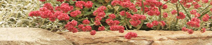
For the past few weeks, Anita and I have been enjoying a wildflower planting in the new medians on Carlson Ave near our house. For years Carlson was an oddly humped road that had such a steep cross-slope near the sidewalk that the car door would hit the curb before it opened all the way and bicycling felt treacherous. To fix that, the city had to lower the street more than two feet to bring it down below the sidewalk, and in the process they also had to lower all of the utilities. The entire project took more than two years, involved all kinds of blocking of cross-streets and traffic, and was hugely inconvenient. But all is now forgiven, as far as I’m concerned, because the city added a median to the street and filled it with twelve blocks worth of wildflowers, many of them native. I’m happy to have my roads blocked if it means I get to drive and bicycle past wildflowers.


So far, I’ve seen California Poppies, Bachelor Buttons, Tidy Tips, Baby Blue Eyes, Alyssum, Lupine, and a few Snapdragons blooming, and there is a lot of Clarkia waiting for next month.
Hmmm…. Be careful what you praise on the internet. The same day that I put this post up, the city weedwacked all of the wildflowers. I’m guessing the planting grew too tall and was blocking visibility, but the city might also be ready to plant trees now. Farewell (to Spring), Clarkia, we never saw you bloom.
— Coda — Apparently an elderly driver got into an accident because of the reduced visibility caused by the wildflowers. Unfortunate for him, and for the wildflowers.
Salt Pond Kite Photos

Salt Pond Montage by Cris Benton, click to see it larger
I meant to post this with my photos of the Salt Ponds, but I got caught up in a bunch of projects and didn’t quite find the time. But I would be remiss if I didn’t mention it. The true master of Bay Area salt pond photography — putting my efforts with a camera merely held in my hand to shame — is UC Berkeley architecture professor Cris Benton who has taken thousands of photos of the salt ponds using kites. Really good stuff, both the images and the fact that he is sending his camera up on a kite. He has slideshows all over the web. There’s a long one here, another one here, a shorter one here, and an interview at ConservationMaven that includes a video about how he uses the kites. He has a blog, Hidden Ecologies, specifically devoted to his salt pond project. Kite photos of salt ponds seems like something that would do well in a contest for the ‘most obscure but interesting’ blog topic on the internet.
You are currently browsing the archives for the bay area category.
Categories
- bay area (7)
- miscellaneous (13)
- plants (69)
- california natives (34)
- bulbs (2)
- wildflowers (10)
- edibles (3)
- trees (14)
- california natives (34)
- private gardens (34)
- lawn to garden (12)
- public gardens (49)
- tilden (9)
- UC Berkeley (3)
- sculpture (32)
- sketchbook (39)
- stone (74)
- sustainability (4)
- trails (13)
- various critters (5)
- wildlands (15)
