The Lawn is Gone

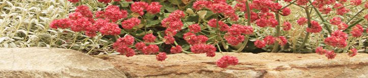
Lawn Converted to Low Water Plants
Just in time to stay with the topic of lawn coversions, a friend of ours in Los Angeles sent us photos of a project we helped with. He’s a former roommate of Anita’s from the years when she was in grad school; he is now married and living in Los Angeles, and he recently bought a home with one of those terrible Southern California front yard lawns. He sent us some photos, asking for a planting plan to replace it. He and his wife wanted to keep the existing citrus tree and Brugmansia, they liked lavenders and succulents, and they wanted to do the work themselves. We sent him a drawing with some big caveats about how we had never gardened in Los Angeles so he would need to double check the plant suggestions with the local nurseries.

Before
That was last winter. This week he emailed us photos of the project, now completed. We had argued for taking out the red walkway heading straight to the door. We suggested replacing it with a DG path, figuring it would be easy to install and easy to upgrade to tile or flagstone in the future. They went ahead and installed the upgraded path right away, hiring a contractor for that part of the project and doing the rest of the work themselves. Most of the plants vary from the ones we suggested (probably a good thing), but they follow the basic layout of the drawing.

The Layout We Suggested
When we named our lawn-conversion/sheet-mulch class Lawn Begone, we were joking about how sheet-mulching can have a certain magic to it, that it’s the closest thing you get to just pointing a wand at the lawn and casting some kind of goofy Harry Potter spell. This project — before and after photos appearing in our inbox, the not-quite-real quality it has because we never physically saw or visited the site, I never saw any of the work happen — takes the magic even a bit further. I’m about as skeptical of designing over the internet as I am of Harry Potter, but in this case it feels a little like we cast a spell and it worked.

Lawn-o Begone-o!!!
Reimagining the California Lawn
This weekend, I went to a talk at Annie’s Annuals by Bart O’Brien, co-author with Carol Bornstein and David Fross of Reimagining the California Lawn. I bought a copy when it first came out, as their previous book California Native Plants for the Garden is pretty much the gold-standard book about California natives and one which I use all the time. I haven’t really read the new one yet. I looked through it enough to make sure that I wanted to keep it, but that’s it so far. I’m teaching our Lawn Begone class at Heather Farms again this year, October 22, so I’ll go through it more carefully when I’m prepping for the class.
In the meantime I was interested to hear one of the authors give a talk on the subject, and I was also just generally interested in what he had to say as he’s one of the prominent figures in the native plant movement and a director at the Rancho Santa Ana Botanic Garden, which I’ve been wanting to see for a long time now. I haven’t been to any of the other talks at Annie’s, but it was pleasant to sit and listen there in their demo garden.
He started with some info about California’s mediterranean climate and then talked about the Garden/Garden project in Santa Monica, which is pretty much the internet’s best comparison of a traditional front yard and a sustainable one. Basically, the city of Santa Monica had two side by side properties and decided to install a lawn/mow-and-blow yard for one and a native garden for the other. They’ve been tracking the results for 6 years now, and it’s of course unfavorable to the mow-and-blow yard. The native garden uses one fifth of the water, generates less than half as much green waste, and requires much less time and money to maintain. Plus the traditional garden looks like a relic from the 1970’s. I linked to a Sustainable Sites Initiative report on it back in the early months of this blog, but O’Brien said the city’s website was really good, and he’s right, it gives a lot more details, including plant lists and construction photos. Worth checking out if you haven’t seen this project before.
He listed 7 design possibilities for replacing a lawn:
Greensward — His term for a no-mow lawn. He liked Carex praegracilis as a no-mow lawn substitute. He said Carex pansa and Carex divulsa were fine, too, he just happened to have the most experience with C. praegracilis. Interestingly, he said that high-elevation carex varieties tend to rarely bloom at lower elevations.
Meadow — An open expanses of grasses, sedges, annual and perennial wildflowers, and bulbs
Rock Garden — Traditionally made of alpine plants but in California just a planting with rocks and low plants
Succulent Garden — Self-explanatory
Carpet and Tapestry Garden — A broad category meant to include most plantings of mixed perennials, grasses, succulents, and shrubs
Kitchen Gardens –Edibles! More relevant for backyard lawns around here.
Green Roof — He joked that this got included because his co-author David Fross is a green roof expert.
He listed 4 ways of eliminating the lawn:
Sod cutter — A lot of work and it doesn’t get rid of the problem weeds of the Bay Area: Bermuda Grass, Oxalis, and Bindweed
Sheet-mulch/Lasagna method — He was rather neutral about it. Not skeptical or dismissive, but not as enthusiastic as I am. (I think it’s far and away the easiest and best way to remove a lawn.) The book says to cover the layer of newspaper with at least 12 to 24 inches of organic matter, but that is excessive. The general consensus is that 4-6 inches of organic matter is the right amount, and I’ve done it successfully with just two or three inches of mulch when it wasn’t practical to mound any higher because of grading issues. He didn’t discuss the process in depth during his talk.
Solarization — He says it takes three months to solarize the soil for the wildflower meadow at Rancho Santa Ana. It’s most effective at combatting annual grasses, actually increases germination with some things like lupines, and is not likely to work well in cooler parts of the Bay Area. I’m not enthusiastic about pasteurizing the soil for a garden.
Judiciously applied chemicals — He removed his own lawn years ago by letting it go brown, then watering it to stimulate growth of the Bermuda grass, and then spot-spraying the growth. He repeated this cycle for three years to completely eradicate his deeply-rooted Bermuda grass. This sounds crazy, toxic, and impractical to me.
He said that he let his garden go completely dormant once, as an experiment, one year when Southern California had only 2.7 inches of rain all winter. Almost all of his plants survived but they looked dead and he was cited by the city for having such a brown unattractive landscape. The city backed off when he told them about his credentials and what he was doing.
He finished by talking about individual plants that he liked and he gave out a list of recommendations which was rather varied, ranging from Dudleyas to Sedums to Buckwheats to Wild Grapes. His focus was on native plants, though I like that the new book gives info on a lot of non-natives too. There were a lot of questions from the audience and he said other things I’m not remembering at this moment and by the end everyone seemed gung ho to go right ahead and remove their lawns. Good stuff.
Salt Pond Kite Photos

Salt Pond Montage by Cris Benton, click to see it larger
I meant to post this with my photos of the Salt Ponds, but I got caught up in a bunch of projects and didn’t quite find the time. But I would be remiss if I didn’t mention it. The true master of Bay Area salt pond photography — putting my efforts with a camera merely held in my hand to shame — is UC Berkeley architecture professor Cris Benton who has taken thousands of photos of the salt ponds using kites. Really good stuff, both the images and the fact that he is sending his camera up on a kite. He has slideshows all over the web. There’s a long one here, another one here, a shorter one here, and an interview at ConservationMaven that includes a video about how he uses the kites. He has a blog, Hidden Ecologies, specifically devoted to his salt pond project. Kite photos of salt ponds seems like something that would do well in a contest for the ‘most obscure but interesting’ blog topic on the internet.
Eden Landing Ecological Reserve

Last week I went to Eden Landing Ecological Reserve, a new reserve in the former salt ponds you see as you get on the San Mateo Bridge heading west. It’s part of the larger South Bay Salt Pond Restoration Project, the biggest wetlands project in California. Strange place, and very different from my mental images of the bay area. I still can’t quite wrap my brain around the idea of the Bay Area as one of the world’s major salt producers. Actually, though, it’s a natural result of the topography (south of Hayward, the bay averages only 1-3 feet in depth) and the dry-summer climate. Salt forms naturally in the shallow areas of the bay and has been harvested since the times of the Ohlone. The first salt ponds were built in the 1850’s and were developed like other forms of agriculture, small plots consolidating into larger and larger ones. Nowadays, Cargill, the giant corporation that’s currently recalling ground up turkey, is the last one still producing salt, 650,000 tons per year according to their website. In 2003, they consolidated their production and sold/donated-for-tax-write-offs over 15,000 acres (25 square miles) which are slowly being turned into nature reserves.

NASA aerial photo of the salt ponds, Eden Landing is towards the upper left
Eden Landing is only recently opened to the public and is still a work in progress. There are levee roads to walk on, former ponds in various stages of restoration, lots of birdlife, weedy pioneer plants with a few new native plantings at the margins, and the ruins of one of the salt production facilities. It’s the kind of landscape that is rather bleak in full sunlight, but beautiful in the first and last hours of the day.


The main focus of the restoration project has been to open the dikes and return the landscape to tidal wetlands and create habit for endangered wildlife such as snowy plover, clapper rail, black rail, and salt marsh harvest mouse. I only saw the more common species of wetland birds, but lots of those. The ruins of the salt works and about 10% of the salt ponds are going to be kept as a remnant of the site’s history and as photographer bait.


The ponds are most striking when you look down on them from the sky and see the colors of the micro-organisms living in the water. Different colors form depending on the salinity of the water: green, rust brown, orange, milky pink, and at the highest salinity a shocking purple. I could see rust in one pool and pink in another when I leaned out over them and looked downward. The NASA aerial photo below is completely untouched; those are the natural colors of the ponds.

NASA Aerial View of the Cargill ponds
QUEST did a segment on the project, focusing on the southernmost of the three sites, Alviso:
One of the areas that I saw on my visit (but didn’t photograph) was opened to Alameda Creek this week and will soon be opened to the bay.
— Addendum 10/7/11 —
Salt Pond Montage by Cris Benton, click to see it larger
The true master of Bay Area salt pond photography — putting my efforts with a camera merely held in my hand to shame — is UC Berkeley architecture professor Cris Benton who has taken thousands of photos of the salt ponds using kites. Really good stuff, both the images and the fact that he is sending his camera up on a kite. He has slideshows all over the web. There’s a long one here, another one here, a shorter one here, and an interview at ConservationMaven that includes a video about how he uses the kites. He has a blog, Hidden Ecologies, specifically devoted to his salt pond project. Kite photos of salt ponds seems like something that would do well in a contest for the ‘most obscure but interesting’ blog topic on the internet.
Yosemite Falls

Yosemite Falls
‘…a trail which was almost like a symphony, stopping, moving, looking, listening, and so on. I wanted to make this… but not to make it clear that there was a designer here… I wanted to leave it to the point that people would assume that it had always been that way.’ Lawrence Halprin
Along with the north coast, I went to Yosemite several times in the last couple months. Absolutely amazing place, as the millions of people who visit annually can all attest. I used to be bothered by the crowds, but I’ve learned to navigate the park and appreciate it without feeling bothered by them. Bringing my bicycle with me has helped immeasurably. The Valley’s a beautiful, flat place to ride around in, and a bicycle is the key to avoiding the daily traffic jams. (The park service really needs to figure out a way to get people parking outside the valley and just using bikes and shuttle buses inside. I’m skeptical it will ever happen, but I can dream, right?) Climbing has also helped me love the valley. Obviously because the climbing is so incredible, but also because I’ve ended up spending long periods of time sitting and staring at the views. And not just on the climbs. Most days I would meet up with my climbing partner at the bicycle parking at Lower Yosemite Falls, and while I waited for him, I started to really appreciate the effect that the view of the falls has for people.

Yosemite Falls
It’s the tallest falls in North America, 2,425 feet, and probably the single most viewed and photographed in the world. Lawrence Halprin redesigned the approach trail and picnic area a few years ago, and there is a lot of stonework done by the same company that did all of the stonework at Stern Grove. I don’t really remember what the approach was like before the redesign and the only ‘before photo I’ve seen is a glimpse in the video I linked above, but I remember a parking lot and a lot of crumbling asphalt. I’m pretty sure the framed view of the falls was already cleared, but possibly with the trees starting to grow back in and obscure the view again, and with a bathroom in the foreground instead of the dramatic allée. The redesign took out the parking area, made the trail into a loop, and rehabbed a lot of degraded habitat areas. It upgraded the materials and it channeled people’s movement so they would hit the key viewpoints without trampling on the vegetation or eroding the banks of the creek. And the work was done with enough subtlety and transparency that, as Halprin was hoping, most people probably don’t realize that their experience was crafted by a designer.

Yosemite Falls Approach
There’s a summary of the project here.

Yosemite Falls Approach Trail
North Coast Sketches

Goat Rock State Park
As I said in my last post, I made some vacation time for myself the last month or two. Not a continuous vacation, but I made it out of town for a three day weekend almost every week, to Yosemite several times and up the coast twice. While on those trips, I made an effort to do some sketches. In the scheme of things, I’m probably more partial to photos, but sketches are good too, and I find myself doing more and more drawing for work. All of these are from the Jenner area, three in the vicinity of Goat Rock and one at Fort Ross.

Goat Rock State Beach

Fort Ross

Sunset Rocks at Goat Rock State Park
Categories
- bay area (7)
- miscellaneous (13)
- plants (69)
- california natives (34)
- bulbs (2)
- wildflowers (10)
- edibles (3)
- trees (14)
- california natives (34)
- private gardens (34)
- lawn to garden (12)
- public gardens (49)
- tilden (9)
- UC Berkeley (3)
- sculpture (32)
- sketchbook (39)
- stone (74)
- sustainability (4)
- trails (13)
- various critters (5)
- wildlands (15)
-
MY FIRM
- cummingslandarch
Garden Blogs -- California
- A Growing Obsession
- Bay Area Tendrils
- Blue Planet Garden Blog
- Cactus Jungle
- Camissonia's Corner
- Curbstone Valley
- Deborah Small's Ethnobotany
- Far Out Flora
- Floradora
- Form and Foliage
- From Seed to Table
- GardenBook
- Gayle Madwin's Journal
- Gossip in the Garden
- Laguna Dirt
- Lost in the Landscape
- My Back 40 (Feet)
- Nature ID
- Overall Gardener
- Rooted in California
- Sierra Foothills Garden
- Town Mouse & Country Mouse
- UCB Botany Photo of the Day
- Wild Suburbia
Garden Blogs -- Out of State
- Arizona Plant Lady
- Bicycle Garden
- Cold Climate Gardening
- Creative Flux
- Danger Garden
- Digging
- Ellis Hollow
- Fairegarden
- Flower Hill Farm
- Garden Rant
- Garden Walk, Garden Talk
- Gardener's Eye
- Gardening Gone Wild
- Greggo's Garden
- Grounded Design
- In the Garden
- Jean's Garden
- Jeffrey Bale's World of Gardens
- May Dreams Gardens
- New Perennialist
- Outside Clyde
- Plant Fanatic in Hawaii
- Randy and Meg’s Garden Paradise
- Restoring the Landscape with Native Plants
- Rhone Street Gardens
- Seed Scatterer
- Serenity in the Garden
- Studio G
- View from Federal Twist
- WiseAcre Gardens
- Zanthan Gardens
Garden Blogs -- Outside the US
Graphic/Art Blogs
Miscellaneous Blogs
Nurseries for California Natives
Stone Sites
- Building Stone Institute
- Clonehenge!
- Dry Stone Conservancy
- Dry Stone Walling Assn. of Canada
- Geotripper
- In the Company of Stone
- Language of Stone
- Megalithic Portal
- Megaliths and Sheep
- Noguchi Museum Tumblr
- Oakland Geology
- Quarries and Beyond
- Rock Art Blog
- Stone Art Blog
- Stone Project
- Stone Soup
- Stone World
- Stone-Ideas
- StoneChat
- Stories in Stone
- The Stone Foundation
- WallingWonderland
- Walls Without Mortar
Useful Lists
- Audobon Plants Birds List
- Deer Resistant Plants
- Dry Gardening Plant List
- Fire Resistant Guidelines
- Fire-Resistant Plant List
- Fruit Info for SF — CRFG
- Fruit Info for SF — UC Davis
- Oak Root Fungus Lists
- Planting Times for the Bay Area
- Planting Under Eucalyptus
- Planting Under Oaks
- UC Bird Alliance
- WUCOLS Database
- Yerba Buena Nursery Deer Page
Useful Websites
- BugGuide
- Cal Poly Tree List
- California Horticultural Society
- California IPM
- Center for Urban Forest Research
- Dictionary of Botanical Terms
- Las Pilitas Cal. Native Plant Database
- Pacific Bulb Society
- San Marcos Cal. Natives Page
- StopWaste
- Stormwater Solutions
- Suncrest Plant Database
- Sunset Zones
- Sustainable Sites Initiative
- Tom Clothier’s Garden Walk & Talk
- Urban Farmer
Useless Websites
-
Archives
- March 2026
- January 2026
- December 2025
- October 2025
- September 2025
- August 2025
- June 2025
- May 2025
- March 2025
- November 2024
- September 2024
- August 2024
- January 2024
- October 2023
- September 2023
- August 2023
- June 2023
- March 2023
- January 2023
- December 2022
- October 2022
- September 2022
- August 2022
- October 2020
- April 2020
- March 2020
- February 2020
- January 2020
- December 2019
- November 2019
- October 2019
- September 2019
- June 2019
- May 2019
- February 2019
- January 2019
- December 2018
- November 2018
- October 2018
- September 2018
- July 2018
- June 2018
- May 2018
- April 2018
- March 2018
- December 2017
- November 2017
- October 2017
- September 2017
- August 2017
- July 2017
- June 2017
- May 2017
- March 2017
- February 2017
- December 2016
- November 2016
- October 2016
- June 2016
- May 2016
- April 2016
- March 2016
- February 2016
- December 2015
- October 2015
- August 2015
- July 2015
- June 2015
- May 2015
- April 2015
- March 2015
- February 2015
- December 2014
- October 2014
- September 2014
- August 2014
- May 2014
- April 2014
- March 2014
- February 2014
- December 2013
- November 2013
- October 2013
- September 2013
- July 2013
- June 2013
- May 2013
- April 2013
- March 2013
- February 2013
- January 2013
- November 2012
- October 2012
- September 2012
- August 2012
- July 2012
- June 2012
- May 2012
- April 2012
- March 2012
- February 2012
- January 2012
- December 2011
- November 2011
- October 2011
- September 2011
- August 2011
- July 2011
- June 2011
- May 2011
- April 2011
- March 2011
- February 2011
- December 2010
- November 2010
- October 2010
- September 2010
- August 2010
- July 2010
- June 2010
- May 2010
- April 2010
- March 2010
- February 2010
- January 2010
- December 2009
- November 2009
- October 2009
- September 2009
- August 2009
- July 2009
- June 2009
- May 2009
- April 2009
- March 2009
- February 2009
- January 2009
- December 2008
- November 2008
