
Archive for the ‘historic’ Category
Mitla Stone Mosaics

Along with Monte Alban, I visited Mitla, another Zapotec site but from a later period and with a much different feel. The ruins are in the middle of a town, which makes for a strange juxtaposition, the second stories of several houses peaking over one of the walls and the town’s catholic church incorporating a couple of the old walls into its construction. I wandered onto the site before I even realized it, and at first glance it didn’t seem dramatic. But then I saw the stone mosaic panels and I was completely enchanted. I’ve never seen anything quite like them.

The mosaics are wonderful, made with hundreds of individual stones fit together into repeating patterns, like brick diaperwork but with hand cut stone. I’ve read that the panels are based on weaving patterns. Though I think that theory is to some extent just speculation, it certainly seems plausible, and it’s fascinating to think of these as stone textiles and the masons as weavers. I’ve done a little bit of stone fretwork like this, and I am blown away that people did this a thousand years ago using just stone-bladed tools and maybe some form of abrasion.

The stone framing around the mosaic panels is quite sophisticated as well. The walls are three or four feet thick, and the panels are inset and laid as a veneer, with corniced stone courses overhanging them. It’s a more refined form of the detailing at Monte Alban, with a skill level that is obviously much higher, but also a stone that is easier to work as well. The stone is trachyte, a volcanic rock that is soft and relatively easy to work. The blocks have admirably crisp edges, though they are not standardized; virtually every course has an odd-dimensioned ‘closer’ stone to resolve the variations in the stones. Some of the courses are battered at the bases of the wall, and many of the stones are slightly trapezoidal instead of perfectly rectangular. Individual stones vary from fifteen-foot-long lintels and massive cylindrical columns that must weigh over ten tons to pieces the size of a finger.

The recessed stones in the mosaics were covered by red stucco when the site was occupied. Traces are visible if you click the photos to see them larger.

There are about 150 different panels. I didn’t take a photo of every single one, but quite a few of them are below. (more…)
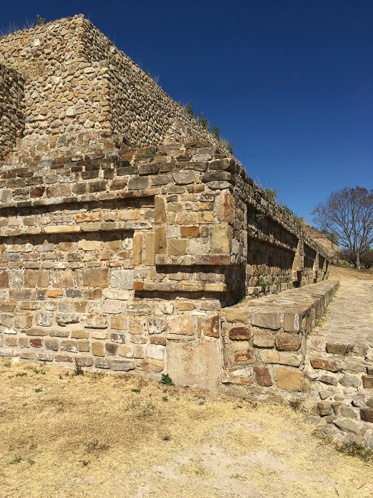
Monte Albán Stone

On my Oaxaca trip I went to Monte Albán, a Zapotec archeological site just outside of Oaxaca City. It’s one of the best ruins that I’ve visited, wonderfully sited on a ridge with views of the surrounding valley, though the air was depressingly smoggy when I visited. I’ve read a bit on the history of the site, but for the most part I just admire it as a stonemason and designer. The thousand plus years of builders did a terrific job, with a beautiful layout and detailing.


Virtually everything on the site is laid out orthogonally except this one building with a strange pentagonal shape in the main plaza’s central cluster. It’s sometimes called the ‘Observatory’ because it’s believed to be aligned with a a star cluster. I don’t know if that’s true or not, but the shape and alignment add an element of mystery. It felt like the masterstroke of the site.


The stonework is beautiful, with coursed, rectangular stone and crazy-patterned, irregular stone often combined in the same wall, sometimes with carved stelae as well. There are several kinds of corners: plumb, battered, lazy, and corniced; and three kinds of vertical surfaces: plumb and battered walls, and the angle made by the steps to the buildings. It’s great how they all combine; there’s enough repetition to give it cohesion but enough contrast to make it interesting.


That’s a beautiful corner detail no matter what century you build it in.


Some of the mortar joints have pebbles in the mud, probably for practical reasons but also creating a nice ornamental effect.


I’m note sure if these stelae are original; a lot of the stelae were moved inside to the site’s museum for protection and replaced by replicas; that’s clearly not the original mortar around these ones. The stelae are subtle but quite nice, worth clicking on to see them larger. Photos of stelae inside the museum are below the jump.

Chaco Canyon Stonework


Last February Anita visited Chaco Canyon in New Mexico. Beautiful place, the photos fascinate me. I love seeing the different eras of the stonework as the masons became more skilled and ambitious, and it’s wonderful how the ruins display the cross-sections of the walls. A place I need to some day see in person.
Save Sugar Pine Bridge?

The National Park Service has released its new plan for Yosemite. In 1987, Congress designated the Merced and the Tuolumne as Wild and Scenic Rivers, and now after years of study the park has put together a plan to comply. I’ve been reading through some of the plan, trying to understand the details, but I haven’t made a lot of headway, and the plan is only open for public comment until the 18th. The report is here with links to a summary and information about commenting.
From what I’ve read, a lot of the proposals make sense. For instance, the proposed expansion of Camp 4 is desperately needed. During the high season, people start lining up hours before sunrise and by 6AM there’s a line of people in sleeping bags waiting for the kiosk to open, essentially camping out in hopes of getting a campsite. I don’t even try to get a site any more. So that proposal is easy to support.
Proposed development in the west end of the valley, near El Cap Meadow, is more of a concern. I LOVE El Cap Meadow, in large part because it is one of the less developed parts of the valley. I would be sad to see it change. I haven’t read deep enough into the plan to find out the details of what is planned. The Access Fund, a climbing advocacy group, has a form letter that more or less represents my point of view until I get a chance to find out a bit more.
I also wish I knew more about the proposal to remove Sugar Pine bridge, the stone-clad bridge near Curry Village. According to the report, the bridge impedes the river’s flow during high water. You can kind of see in these Library of Congress photos that the abutments are out in the flow of the river.


I wish I was going to have a chance to read more about that before the comment period ends. If anyone know or finds any substantial info, please let me know. Sugar Pine is probably not the single most iconic of the Yosemite bridges, but as a group the stone bridges are quite wonderful. There aren’t a lot of stone bridges in California. It would be shame for one of them to go.
BGS Quarry Photos

Corncockle Quarry, Lochmaben. Dumfriesshire ‘Close-up view of splitting the sandstone by the ‘chisel wedge’ method. Eleven wedges are seen being forced into the stone to separate a block from the main mass of rock. Three quarrymen in typical working clothes are seen, two holding large sledge or striking hammers used for driving in the wedges. A selection of picks rest on the rock behind.’
A couple of photos in STONEZINE led me to the website of the British Geologic Survey which has some great photos from quarries and other sites of geologic interest. These photos here are all 1930’s era, but at some quarries the techniques haven’t changed that much. Pallets of stone still sometimes come marked with the name of the individual who quarried them.

Rubislaw Quarry. Aberdeenshire ‘View at surface, showing dressed and partly dressed building stones. The granite is mainly used for building and monumental work. Two quarrymen prepare a granite block to be split by using the plug and feather method. They are using pneumatic drills to drill short holes around the block into which the plug and feathers are inserted. These are then systematically struck with hammers, causing the block to split. Another quarryman appears to be using a measuring stick against a large block of granite.’

Silver Grey Quarry, Creetown. Kirkcudbrightshire ‘A large granite block being prepared for splitting on the quarry floor by means of ‘plug and feathers’ method. Two quarrymen can be seen inserting the ‘plug and feathers’ into a large granite block. A recently separated block can be seen in the foreground. A series of narrow holes a few inches apart were drilled by a pneumatic drill. Two half cylinders of steel called ‘feathers’ were inserted into all the holes. A steel wedge-shaped ‘plug’ was then inserted. The plugs were then hit in succession with a hammer and a straight split in the granite block would result.’

Silver Grey Quarry, Creetown. Kirkcudbrightshire ‘A large granite block split into two on the quarry floor using the plug and feathers method. Two quarrymen, one wielding a crowbar, displaying recently split large blocks using the ‘plug and feather’ method. A series of narrow holes a few inches apart were drilled by a pneumatic drill. Two half cylinders of steel called ‘feathers’ were inserted into all the holes. A steel wedge-shaped ‘plug’ was then inserted. The plugs were then hit in succession with a hammer and a straight split in the granite block would result.’

Craignair Hill Quarry, Dalbeattie. Kirkcudbrightshire ‘A view of the open kerb-making yard. Two workers can be seen standing at barrels filled with sand on which the stone was dressed. Completed kerbs are seen stacked to the left of the photograph.’

Corsehill Quarry, Annan. Dumfriesshire ‘The masons are shown wielding wooden mallets called ‘mells’ and chisels as they work on the stone. On the left are sawn blocks; some show small holes cut in the faces. These holes are used for gripping and handling the blocks with a dog and chain sling as in the centre foreground.’

Craignair Hill Quarry, Dalbeattie. Kirkcudbrightshire ‘Granite sett-making on the yard floor. A sett-maker wielding a hammer at work in front of his hut. On the left are the rough unprocessed blocks while to the right are carefully stacked finished setts. A ‘sett’ is stone roughly squared for paving.’

Craignair Hill Quarry, Dalbeattie. Kirkcudbrightshire ‘Sett-making on the yard floor. Two workers (and a dog!) are seen. One is working on a sett. Note the chisel faced hammer he is using and the very large pile of completed setts piled carefully behind.’

Locharbriggs Quarry. Dumfriesshire ‘A close-up showing the ‘shot-grove’ and chisel wedge method of splitting stone. Widely spaced holes are drilled and filled with black powder; once blown and the blocks dislodged, chisel wedges are driven in along planes of weakness (usually bedding planes) to further work the stone. Note the quarryman wielding the large crowbar.’

Locharbriggs Quarry. Dumfriesshire ‘A close-up showing the ‘shot-grove’ and chisel wedge method of splitting stone. Widely spaced holes are drilled and filled with black powder; once blown and the blocks dislodged, chisel wedges are driven in along planes of weakness (usually bedding planes) to further work the stone. Note the quarryman wielding the large crowbar.’

Rubislaw Quarry. Aberdeenshire ‘General view of floor and west wall of this granite quarry, showing west-south-westerly running joints and material brought down by blasting. Holes, six metres long were drilled using pneumatic drills, black powder was inserted and then blasted. The natural weakness of the joint planes was used in deciding where to drill and blast.’
Middle Harbor Training Wall Memorial

This little jetty sticking out into the mudflat (click on all of these to see them bigger) is a memorial to one half of the Bay Area’s largest and most ambitious drystone construction, the Oakland Harbor Training Walls. It’s in Oakland’s Middle Harbor Shoreline Park, which is a rather incongruous park. The park is out in the middle of the port surrounded by industrial activity, there’s a ton of lawn which no one ever uses and in fact the geese have turned rather unusable, and there are a bunch of big landscape elements that reference the history of the port: the shade structure in the photo below, a concrete path that marks the footprint of a giant 19,000 square foot building that they took down, and the rock jetty that commemorates the port’s north training wall.

The harbor’s north and south training walls were two long jetties designed to ‘train’ the tide. Unlike a typical riprap jetty made of haphazardly dumped piles of rock designed to absorb wave or tidal energy, each rock in the training wall was fitted by stoneworkers to give the wall a smooth face that would accelerate the water instead of slowing it down. Back in the 1800’s, Oakland’s harbor was shallow and it tended to fill with silt; ships could only enter it during high tide. The idea of the training walls was to channel the tide’s energy so that when the tide went out it would also suck all the silt out with it, reducing the need for dredging. The walls were started in 1874 and took twenty years to build, with some impressive stats: 310,000 tons of stone, 500,000 square feet of wall, 20 feet wide at the base, 8 feet wide at the top, 6 feet above the low water point. The north wall was 9500 feet long, the south wall 12,000. Apparently the walls worked; the signage says the port’s activity went up 2000% after they were built.

The south wall is still there, but the port the north wall out in 2001 when they widened the channel so bigger container ships could use it; as part of the approval process, they used some of the north wall’s rock to build this memorial. I didn’t do all that good with my photos of it (there’s a better one at Oakland Geology) and I might try again some time when the tide is in or I might try to find a good view of the south wall. Honestly, though, I think the appeal is more intellectual than aesthetic.

It looks a little better with some sun flare drama. You can see the contrast between the training wall’s fitted stone (above) and the riprap’s rough faces (below).


Overall, though I said it was incongruous, the park is also pretty cool. The ships and cranes and machinery right next to the park are all impressive. There’s also a habitat planting with some natives struggling against weeds and a path out to a great view of the Bay Bridge and the city. The water area of the middle harbor is being converted into a mudflat, slowly getting filled with the silt from dredging of the channel. It’s a good place to see water birds.

And the park is a great place to see the sunset. Information and a map of the park is here, a historic photo with the training walls visible on the left side is here.

You are currently browsing the archives for the historic category.
Categories
- bay area (7)
- miscellaneous (13)
- plants (69)
- california natives (34)
- bulbs (2)
- wildflowers (10)
- edibles (3)
- trees (14)
- california natives (34)
- private gardens (34)
- lawn to garden (12)
- public gardens (49)
- tilden (9)
- UC Berkeley (3)
- sculpture (32)
- sketchbook (39)
- stone (74)
- sustainability (4)
- trails (13)
- various critters (5)
- wildlands (15)
